-
대학/대학원
-
연구/산학
-
대학생활
-
입학/취업
-
커뮤니티
-
대학소개
-
개교 80주년
커뮤니티
부경투데이
- 국립 부경대학교의 다양한 모습과 소식을 접하시면 부경대학교가 한번 더 가까워집니다.
| YTN 사이언스에 소개됐다(Introduced on the YTN Science Channel) | |||
| 작성자 | 대외협력과 | 작성일 | 2021-09-27 |
| 조회수 | 530 | ||
| YTN 사이언스에 소개됐다(Introduced on the YTN Science Channel) | |||||
 |
대외협력과 |  |
2021-09-27 |  |
530 |
YTN 사이언스, 부경대 미세먼지 관측 시스템 기술 ‘주목’
- ‘다큐S프라임’에 노영민 교수 연구팀 활약 소식 소개
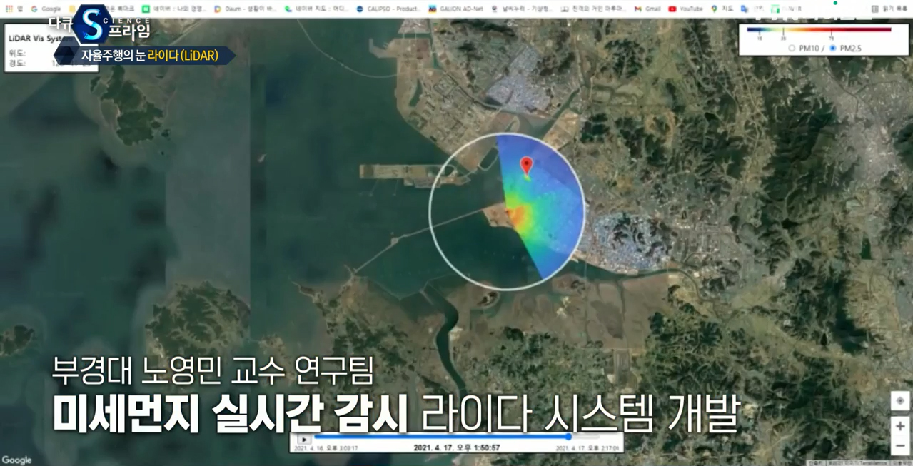
△ '다큐S프라임' 프로그램 화면 갈무리.
 부경대학교 노영민 교수(환경공학과) 연구팀의 활약상이 ‘YTN 사이언스’에 소개됐다.
YTN 사이언스는 지난 9월 23일 ‘다큐S프라임’ 프로그램의 ‘자율주행의 눈, 라이다’ 편에서 라이다 활용기술 사례로 노영민 교수 연구팀이 개발한 ‘스캐닝 라이다 시스템’을 소개했다.
이 방송은 4차 산업혁명의 핵심기술이라고 할 수 있는 라이다 기술을 소개하며, 이 기술은 과거 기상관측이나 지형을 정밀히 그리거나 비행기 착륙 유도 등에 국한해 사용됐지만 지금은 우리 일상 깊숙이 스며들고 있다고 밝혔다.
라이다(lidar)란 라이트(light)와 레이더(lader)의 합성어로, 신호를 발사하여 물체가 반사되는 것을 확인하는 기술이다. 레이더와 원리가 유사하지만 발사하는 신호가 단파장의 레이저 펄스로 돼있어 정밀하게 물체를 이미지화 할 수 있다.
라이다 기술은 최근 자율주행 기술, AR 가상현실 기술, 공간 스캐닝을 통한 3D 공간모델 뿐만 아니라 농장 대형가축 관리, 기후변화 보존, 산림 관리, 하수 유지 보수 등 현실적인 응용과 적용으로 이어지고 있다.
이번 방송에서 이 같은 라이다 기술 활용 사례로 노영민 교수팀이 개발한 고해상도 미세먼지 농도 분포 감시용 스캐닝 라이다 시스템이 소개됐다.
이 시스템은 라이다 기술에 스캐닝 방식을 도입해 반경 5 km 내 관측 영역을 30 m의 고해상도로 미세먼지 질량농도를 미세먼지와 초미세먼지로 구분해 산출할 수 있는 시스템이다.
방송은 원격으로 미세먼지 실태와 현황 배출량을 파악할 수 있는 기초자료를 산출할 수 있을 것으로 기대된다고 밝혔다.
방송 영상은 YTN 사이언스 홈페이지와 유튜브(YTN 사이언스)를 통해 확인할 수 있다. <부경투데이>
YTN Science showed interest in the Fine Dust Observation System Technology that PKNU has
'Docu S Prime' introduced the latest update of Prof. Noh Young-Min's research team
The activities of the research team of Professor Noh Young-Min (Department of Environmental Engineering) of Pukyong National University have been introduced on the channel ‘YTN Science’.
YTN Science introduced the 'Scanning LiDAR (Light Detection And Ranging) System' developed by Professor Noh Young-Min and his research team as an example of lidar application technology in the episode ‘Eye of Autonomous Driving, LiDAR’ of the program ‘Docu S Prime’ on September 23rd.
This broadcast introduced lidar technology, which can be said to be the core technology of the 4th industrial revolution. In the past, this technology was only used for meteorological observations, accurately drawing terrain, or guiding airplane landings, but now it is deeply involved in our daily lives.
Lidar is a compound word of light and radar, and it is a technology to check the reflection of an object by emitting a signal. Although the principle is similar to that of radar, the emitted signal is composed of short-wavelength laser pulses, enabling precise images of objects.
Lidar technology has recently led to practical applications and applications such as autonomous driving technology, AR virtual reality technology, and 3D spatial model through spatial scanning, as well as farm large-scale livestock management, climate change conservation, forest management, and sewage maintenance.
In this episode, a high-resolution scanning lidar system for monitoring the distribution of fine dust concentrations developed by Professor Noh Young-Min's research team was introduced as an example of the use of lidar technology.
This is a smart system that can calculate the mass concentration of fine dust by dividing it into fine dust and ultrafine dust with a high resolution of 30 m in an observation area within a 5 km radius by introducing a scanning method to lidar technology.
In the episode, it is expected to be able to calculate basic data that can remotely grasp the current state of fine dust and current emission.
You can check the video on the YTN Science website and YouTube (YTN Science). <Pukyong Today>